I C E L A N D' s V O L C A N O E Sand BEERENBERG volcano, Jan Mayen | |
Iceland certainly is one of the most interesting places in the world for geologists. Sitting smack on the Mid Atlantic Spreading Rift it is torn in the middle by two continents pulling apart. The earth's crust tears, opens, and new material from below rises and creates new land. The tearing of crust causes numerous earthquakes in Iceland every day, and now and then, magma rises causing one of its 30 active volcanic systems to erupt. 13 different volcanoes have erupted since settlement in 874 AD, and over the last 500 years Icelandic volcanoes have erupted a third of the total global Lava output. Learn more about Icelandic volcanoes at the Volcano Hotspot blog If you click on the sun button  on top of a webcam a clear weather image from that webcam will pop up to help you picture the lay of the land when the mountain is shrouded in dark clouds for days or weeks! on top of a webcam a clear weather image from that webcam will pop up to help you picture the lay of the land when the mountain is shrouded in dark clouds for days or weeks!
| |
|
|
|
|
| |
|
MIÐHUS ? sec. O-Web O-IMG
| |
? min. O-IMG
| |
|
HEKLA updated every 5 min. Min. O-IMG
|
Strain at HEK Hekla O-IMG ? sec. 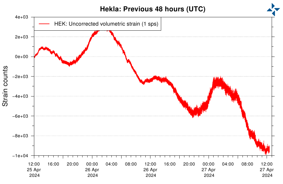
|
These three live streaming cameras and a lot of others can be found on Live from Iceland I have not set the players to Autoplay, as they are taking a lot of bandwidth together. | |
|
Iceland: HEKLA LIVE!
O-Website |
Iceland: EYAFJALLAJÖKULL LIVE!
O-Website |
|
Iceland: KATLA LIVE!
O-Website |
MAPS & Stuff |
|
Iceland: HEKLA (GFZ) O-Web 5 min. O-IMG
|
|
Jan Mayen | |
Jan Mayen / Norw. 40-km-long Jan Mayen Island lies in the Norwegian Sea along the Mid-Atlantic Ridge about 650 km NE of Iceland. It consists of two geographically distinct parts. Nord-Jan has a round shape and is dominated by the 2,277 m (7,470 ft) Beerenberg with its large ice cap, which can be divided into twenty individual outlet glaciers. South-Jan is narrow, comparatively flat and unglaciated. Its highest elevation is Rudolftoppen at 769 m (2,523 ft). | |
|
WEBCAM: Jan Mayen: Beerenberg O-Web O-IMG
24-hour-timelapse Play 24-hour-timelapse on LOOKR website Link may not be avaiable at times due to updating the timelapse videos |
 Beerenberg basaltic stratovolcano has a 1-km-wide summit crater and numerous cinder cones that were erupted along flank fissures. It is composed primarily of basaltic lava flows with minor amounts of tephra. Confirmed eruptions at Beerenberg date back to the 14th century. The Sor-Jan group of pyroclastic cones and lava domes occupies the SW tip of Jan Mayen. The Holocene Sor-Jan cinder cones, tephra rings, and trachytic lava domes were erupted from short fissures with a NE-SW trend. The island lies at the northern end of the Jan Mayen Microcontinent. The microcontinent was originally part of the Greenland Plate, but now forms part of the Eurasian Plate. |


 Hekla seen from Mjóaskarð in Vatnafjöll.
