INDONESIA & PHILIPPINES | |
 As Indonesia is sitting on the subduction zone between the Eurasian plate and the Indo-Australian plate there is no shortage in geological events. Earthquakes of all magnitudes are daily business, tsunamis have to be reckoned with and, of course, there is a long list of active volcanos, not to mention the many dormant ones. The number of active volcanoes is given as 127 to 147 (by different sources) and there are always some on higher alerts. |
|
 Indonesian webcams generally have a habit of stopping working for days or months, then springing to life for a few days only to go down again for another half year. I try to keep the more reliable ones on top and cross my fingers... Also, some are turned off and show a daylight image over night. Jakarta time: For Lokon add 1 hour, for Gamalama 2 hrs. |
S U M A T R A Gunung Sinabung is an andesitic/dacitic stratovolcano in North Sumatra, elevation 2460 m (8070 ft). This eruption has begun in 2013; it consists of building and destruction of lava domes with heavy ash explosions and pyroclastic flows. Latest eruption started in 2013. First eruption was in 2010 after a 400-year quiet period. | |
|
SINABUNG 1 1 Min. O-IMG
|
SINABUNG 2 1 Min. O-IMG
|
|
SINABUNG 3 1 min. O-IMG
|
SINABUNG 4 1 min. O-IMG
|
|
MARAPI 1 min. O-IMG
|
TALANG 1 min. O-IMG
|
J A V A | |
|
ANAK KRAKATAU 1 1 min. O-IMG
|
ANAK KRAKATAU 2 1 min. O-IMG
|
|
GEDE 1 min. O-IMG
|
TANGKUBAN PARAHU O-IMG
|
|
PAPANDAYAN O-IMG
|
G. GUNTUR O-IMG ? min.
|
|
GALUNGGUNG O-IMG
|
SLAMET O-IMG
|
|
DIENG Volcanic Complex 1 O-Web ? min. O-IMG
|
DIENG Volcanic Complex 2 O-Web ? min. O-IMG
|
|
SUNDORO O-IMG
|
SUMBING O-IMG
|


|
MERAPI 4 sec. O-IMG
|

KELUT 2 O-IMG
|

|
SEMERU O-IMG 1 min.
| |
|
BROMO 1 min. O-IMG
|
IJEN O-IMG
|
B A L I, L O M B O K & S U M B A W A | |
|
AGUNG O-IMG
| |


This loads very slowly after every update, pls. be patient. Updated abt. every 3 minutes. |
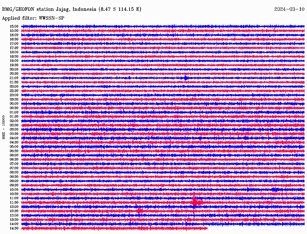
JAGI station is located at the SE tip of Java near Jajag, some 150km to the west of G. Agung. It may record urban noise and/or activity of other volcanoes. (Images: Geofon, GFZ Helmholtz-Zentrum Potsdam). |

Daily earthquake count at Agung. Click on O-IMG for large version. |
E A S T E R N I S L A N D S | |
|
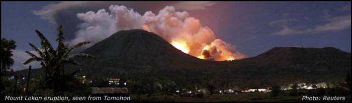
LOKON O-IMG 1 min.
|
GAMALAMA 1 min. O-IMG
|
| |
PHILIPPINESI am delighted that the Philippine Institute of Volcanology and Seismology (PHIVOLCS) is making great progress in Earthquake and Volcano Monitoring including a comprehensive and interactive Earthquake and Volcano Information Portal Site with realtime seismic and infrasonic drumplots for Taal, Mayon and Bulusan, disaster mitigation advice, hazard maps and various volcano webcams.(Taal volcano station map - Mayon volcano station map) Manila time: | |
|
Yacht Club cam via mycam-asia.tv 
This webcam has been down for years, I hope it still exists because it's a lovely view. ~~~ The volcano sits on an island in the middle of Lake Taal, an old caldera lake on the Philippine Island of Luzon. Last eruption: 1977. | |


The following Indonesian webcams showed outdated images at the time of writing, but are worth checking from time to time. | ||||
|
TAMBORA O-IMG |
RINJANI O-IMG
|
|||


MODVOLC hot spot table. Images are at least 20 hrs old. - Displayed are the hot spots of the last 2 days (preceding the 20 hrs lag) for each volcano. Hot spots are shown as small green to red squares. - Click on an img to open large view. There you can change the time span to be displayed by changing the number (of days) for *jperiod=x* in the address bar (without the *). - Refresh with F5. INDONESIA: | ||||||
|
G. Agung |
G. Anak Krakatau |
Batu-Tara |
G. Bromo |
G. Colo |
G. Dempo |
Dieng V. C. |
|
G. Dukono |
G. Egon |
G. Gamalama |
Gamkonora |
G. Guntur |
G. Ibu |
Karangetang |
|
G. Kelud |
G. Kerinci |
G. Lewotobi |
G. Lewotolo |
G. Lokon |
G. Marapi |
G. Merapi |
|
G. Papandayan |
G. Raung |
G. Rinjani |
G. Rokatenda |
G. Sangeangapi |
G. Semeru |
G. Sinabung |
|
G. Sirung |
G. Soputan |
G. Slamet | ||||
PHILIPPINES: | ||||||
|
Bulusan |
Mayon |
Taal |
Pinatubo |
Canlaon |
MODVOLC - MODIS volcano hot spots last 2 days - University of Hawaii New website |
|
|
|
||||||